TopoSurv is a management system for field data, an application to ArcGIS.
TopoSurv imports and calculates survey- and satellite data to ArcGIS database and is a plug-in to ArcGIS. With TopoSurv do you import survey and satellite data from Leica, Trimble and survey data from Sokkia, Topcon (LandXML) and other instruments via different file formats such as ASCII, LandXML, PLM and others. TopoSurv creates a menu in ArcGIS with commands to start TopoSurv, system settings, import from different field collectors and to export data to different field collectors for stake out.
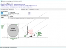
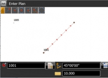
TopoSurv imports survey data from the instruments and reports the data in a survey document where all types of data is reported in different tabs. Survey data, known points, local coordinates, satellite data in latitude, longitude and height as well as satellite data in vector from base station. To make data accessible in ArcGIS the surveyor will use point codes to create layers – tables and there are numerous ways to create geometry for the survey. We recommend to use control codes that gives several choices of not only measure points and lines but also radius, parallel lines, circles and others. TopoSurv works also with attributes all the way from field to database.

ArcGIS extension with geospatial analysis capabilities for mlitary applications.


Comments